Page 1 of 2
WHAT TO MAKE OF THIS DAM LOCATION
Posted: Sat Jan 29, 2011 12:37 pm
by paul.hodgson
Hi Everyone,
Does anybody have any suggestions on the type and location of this dam. The dam is located on a spur line with very little high ground to the North. It is heavily eroded and the water level is very low. I am wondering how the dam is fed? Could it be spring fed. It doesnt appear to sit in a natural water capturing position? Does anybody have any thoughts?
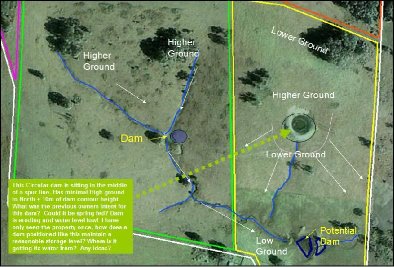 Image Caption:
 This Circular dam is sitting in the middle of a spur line. Has minimal High ground to North + 10m of dam contour height. What was the previous owners intent for this dam? Could it be spring fed? Dam is eroding and water level low! I have only seen the property once, how does a dam positioned like this maintain a reasonable storage level? Where is it getting its water from? Any ideas?
Re: WHAT DO MAKE OF THIS DAM LOCATION
Posted: Sat Jan 29, 2011 1:12 pm
by duane
Paul
The position of wetlands systems (grass covered dams previously) suggests they were always on the highest part of a stepped system.
Two simple things to remember when looking where to place a new dam:
- 1. dont put it when you think you should. Ask yourself WHY?
- 2. make contours as far out from either side of where you decide to place the dam and that the contour level = HWM of the dam
This is CRITICAL. WHY??
Remember how the Australian landscape moved water and fertility.....that is what you are aiming for.
The position of the new dam on your map is all wrong. WHY is that, from what you know of nsf??
Re: WHAT DO MAKE OF THIS DAM LOCATION
Posted: Sat Jan 29, 2011 1:41 pm
by paul.hodgson
Hi Duane, thanks for the response and information regarding location advice regarding new dams.
Can you review my questions regarding the circular dam? I am interested in finding feedback on this particular topic.
Regards
Paul
Re: WHAT TO MAKE OF THIS DAM LOCATION
Posted: Sat Jan 29, 2011 9:58 pm
by duane
This Circular dam is sitting in the middle of a spur line. Has minimal High ground to North + 10m of dam contour height?? Can you explain what you mean by height in +m of dam contour . What was the previous owners intent for this damWho knows....est to ask them or a neighbour, if the original dam owners are no longer around? Could it be spring fed? Yes, quite possibly could be. Dam is eroding and water level low! Dam will lose 2000mm a year just by evaporation!!! I have only seen the property once, how does a dam positioned like this maintain a reasonable storage level? If indeed it was spring fed....the spring! Where is it getting its water from? Any ideas?Already answered above
Re: WHAT TO MAKE OF THIS DAM LOCATION
Posted: Sun Jan 30, 2011 9:01 am
by paul.hodgson
Duane,
I sense alot of scarcasm in your response. My previous request to seek specific answers regarding my original question was not intended to lessen your feedback; however, I sometimes dont understand your posts as I see them as riddles. I make best efforts to learn and understand NSF principles and techniques; however, I am using this forum to get a range on information to help me while at the same time try to learn.
My initial post was to seek information on a particular dam and how it may have been used. I understand that is a difficult question to ask, as it is for me, as I have only briefly seen it and not in a position to question current owners or neighbours.
Your original reply I did not fully understand and also detailed "The position of the new dam on your map is all wrong. WHY is that, from what you know of nsf??". If you are going to suggest that it is all wrong, could please support your comments with a reasonable explanation. Maybe a dam is not the right word, but NSF talks about keeping water on your land etc, this location is where the water runs quickly off the farm direct on to the adjoining highway. I dont see that can be good.
Regards
Paul
Re: WHAT TO MAKE OF THIS DAM LOCATION
Posted: Sun Jan 30, 2011 9:36 am
by Joe
From the picture and your description I'm guessing that the structure you refer to is not a dam at all, but a turkey's nest or earth tank. It is simply a water storage, made from banked up clay. The water is pumped in, either from a bore or other supply and gravity fed from the storage to wherever it is needed.
Re: WHAT TO MAKE OF THIS DAM LOCATION
Posted: Sun Jan 30, 2011 10:10 am
by Stringybark
G'day Paul.
I reckon he best way to get the answers to your questions, is to get out there on foot.
Get walking around the property. Take pictures for later reference, when you're at home wondering about a particular aspect.
The next time you walk around there, things will start to make more sense. It never hurts to have several looks. Especially if you are thinking of purchasing.
If possible, take someone else for their different perspective.
Read, or re-read Peters books. I find myself referring back to parts of them when I have trouble understanding a concept or part of the landscape function.
One of the things about NSF that i have realised, is that it's not rocket science. Lots of observation gives the answers.
Re: WHAT TO MAKE OF THIS DAM LOCATION
Posted: Sun Jan 30, 2011 10:20 pm
by duane
Paul....no sarcasm intended....sorry if it came across that way.
I think Joe's answer is probably spot on.
Re your query
"The position of the new dam on your map is all wrong. WHY is that, from what you know of nsf??". If you are going to suggest that it is all wrong, could please support your comments with a reasonable explanation.
I posed my first response as an exercise to gauge where you and others are thinking.
Traditionally, farm dams are placed at the bottom end of a natural flow line. Not always but mostly. Seems obvious doesn't it? But it's incorrect aca NSF.
Anyone like to have a stab at why this is so??
Re: WHAT TO MAKE OF THIS DAM LOCATION
Posted: Mon Jan 31, 2011 7:01 am
by paul.hodgson
Thanks Duane,
I apprechiate your time and everyone esle's in taking the time in posting responses. I much apprechiate it. I am enjoying the forum as a unique and interesting way to learn.
I have much to learn and I eagerly await to tackle my new farm. I will keep you posted and keep a visual diary.
Regards Paul
Re: WHAT TO MAKE OF THIS DAM LOCATION
Posted: Mon Jan 31, 2011 8:52 am
by duane
I asked the following question above
Traditionally, farm dams are placed at the bottom end of a natural flow line. Not always but mostly. Seems obvious doesn't it? But it's incorrect aca NSF.
Anyone like to have a stab at why this is so??
This is NOT a test......but a way of learning, without rote.
Anyone????? Give it a go........
Re: WHAT TO MAKE OF THIS DAM LOCATION
Posted: Mon Jan 31, 2011 10:16 am
by Shirley Henderson
How about creating a level gully (1M in depth) along a contour to hold the water and allow it to seep through or find the natural water flow. Plant plants on the soil lifted out of the gully on the down side, fill with manure, mulch etc to create fertility seeping through the landscape?
Re: WHAT TO MAKE OF THIS DAM LOCATION
Posted: Mon Jan 31, 2011 10:30 am
by duane
I will give everyone a clue:
Water in the Australian landscape moves fertility down and across the landscape. If it's not done properly the effects can be extremely negative.
suggest people read or re-read Peter's position in Chpt 25 p208 , in BFTB on 'Farm Dams: Should we damn them or not for the answers.
Re: WHAT TO MAKE OF THIS DAM LOCATION
Posted: Mon Jan 31, 2011 11:09 am
by Shirley Henderson
I had a look at the chapter Duane. Peter is very clever.
Also chapter 23 page 187 Contouring. Peter says dont go deeper than half a metre and bank up the side below. (because of salt). Also there needs to be 2 channels one above the other for the fresh water and below for the fertility, mulch etc.
I had a stab at it, but should have looked it up in the book first. Next time I will. Good luck Paul hope you do the same. Shirley
Re: WHAT TO MAKE OF THIS DAM LOCATION
Posted: Mon Jan 31, 2011 12:32 pm
by duane
Shirley
Thank you for taking the time to look.....its important for people to do so and not always wait for someone else to give an answer.
It's about observation, as well as reading the stuff in Peter's books and searching properly for the right answer.
Good advice also that you gave to Paul.....the reasons are there in BFTB, for my earlier questions I posed.
And people are more likely to remember the information once they have made an effort to find it.
Re: WHAT TO MAKE OF THIS DAM LOCATION
Posted: Wed Feb 02, 2011 2:42 pm
by Julian
I have a Dam at the bottom of the property, like almost everybody else. I am attempting to practice NSF, but I am not in a position to move my dam up the hill of course.
I can see that all the fertility will eventually end up in the dam, but will deal with that later. My immediate question is watering the animals? A dam lower in the catchment seems the easiest way to hold water thru those dry months for thirsty cattle. If I put a dam in the highest reaches of my property, I dont think it would fill. (Except this year).
